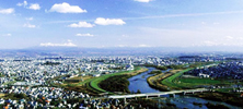
Where is Asahikawa?. Asahikawa is located in Kamikawa County in the middle of Hokkaido, the northern island of Japan. Its population is about 360,000 making it the second largest city in Hokkaido behind Sapporo. Its latitude is 43N (about the same as Bucharest, Romania and Portland, Oregon USA) and its longitude is 142E (about the same as Melbourne, Australia.) Asahikawa is the center of Kamikawa valley, surrounded by Taisetsuzan Mountain Range.
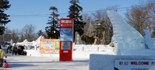
Asahikawa Weather. The difference between the hottest and coldest in a year is dramatic here. Asahikawa holds the Japan’s record of the coldest temperature -41C (-41.8F), measured in 1902 is still unbeatable. In 1090, Asahikawa had the second coldest daily high temperature of -22.5C (-8.5F) in Japan’s history. The coldest daily temperature (-30.2C=-22.36F)was measured in 1977 on the top of Mt. Fuji which is 3776m (12380 feet) elevation. It is really scary to think the hottest temperature of the day is -41C.
The Name "Asahikawa". The native Ainu people called the Chubetsu river that crossed Asahikawa from the east to the west “Chiu Pet” meaning "river with wake". When Japanese immigrants started to settle Hokkaido, they misheard the word as “Chu Pe” meaning "river of the sun". Asahi means the ray of sun and kawa means river in Japanese.
Asahi-bashi(Asahi-bridge). There are many rivers running through Asahikawa and as a consequence there are plenty of bridges. The most famous bridge in the city, “Asahi-bashi” connects the city center to the northern suburbs along Route 40 where the Ishikari and Ushubetsu rivers meet. Asahi-bashi is the one of the 3 most famous bridges in Hokkaido (the other two being the Toyohira-bashi in Sapporo,and the Nusamai-bashi in Kushiro) and the only one still unchanged since being built. It has been painted many times over 70 years with olive green the current choice. It was placed on the Hokkaido Heritage List in 2004 and recognized as the one of Asahikawa's top 8 scenic sites.
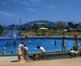
Asahikawa’s main street. Asahikawa’s main street starts from JR Asahikawa station for 10 blocks to the north, pedestrian only street, is called “Kaimono-Koen.” Its formal name is “Asahikawa Heiwa-dori Kaimono-koen” which directly translated means “Asahikawa Peace street Shopping park.” “Kaimono-Koen” was finished in 1972 and became Japan's first pedestrian only outdoor shopping mall. There are many shops and major department stores along Kaimono-Koen separating the business district on the east side and the restaurant and night life district on the west side. Although the city is suffering from an increasingly suburban life-style, Asahikawans still love to be in the city for going out and shopping. Most of Asahikawa's local buses use the bus stops close to Kaimono-Koen as a hub. Kaimono-Koen is a pedestrian-friendly street with both sides heated during winter for easy, non-slip walking.
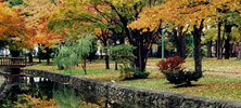
The number of rivers running through Asahikawa is about 170 having about 700 bridges over them. “Kawa (or gawa in some conjugated pronoun forms) ” means river in Japanese, fitting really, with so many rivers converging on such a small place.
Ishikarigawa
Ishikarigawa is the third longest river in Japan and the longest river in Hokkaido, starting its journey from Ishikaridake in Kamikawa-cho, going through Asahikawa, Sapporo and on to the Japan Sea. The name comes from the Ainu “ishikar” meaning “winding river.”
Chubetsugawa
Chubetsugawa starts from Chubetsudake in Biei-cho, making its way through Tenninkyo to merge with Bieigawa in Asahikawa. Its name is derived from the Ainu “Chiu pet” meaning “river with wake.”
Bieigawa
Bieigawa starts from Tsuriganesan (Hanging bell mountain) in Tokachidake Mountain Range, winds through Shirogane Onsen and Biei-cho to merge into the Chubetsugawa. The name “Biei” means “Oily” or “not clear” from the Ainu “Piye.”
Ushubetsugawa
The Ushubetsugawa starts from the hill bordering Toma-cho and kamikawa-cho and merges with the Ishikarigawa over Asahibashi (Asahi bridge). Its name comes from the Ainu “Ushi si pet” meaning “the river with deer tracks.”
Nagayama Shinkawa
Nagayama shinkawa is the newest man-made river in the city, designed primarily to manipulate the Ushubetsugawa’s water level through Nagayama area, the northern part of Asahikawa. Swans and ducks from Siberia visit the banks of this river in spring and fall.
Osarappegawa
The Osarappegawa starts on the border between Takasu-cho and Wassamu-cho and goes through Takasu-cho to merge with the Ishikarigawa. Its name comes from the Ainu “O sar pet” meaning “the end of river, reed, and river.”
 Where is Asahikawa?. Asahikawa is located in Kamikawa County in the middle of Hokkaido, the northern island of Japan. Its population is about 360,000 making it the second largest city in Hokkaido behind Sapporo. Its latitude is 43N (about the same as Bucharest, Romania and Portland, Oregon USA) and its longitude is 142E (about the same as Melbourne, Australia.) Asahikawa is the center of Kamikawa valley, surrounded by Taisetsuzan Mountain Range.
 Asahikawa Weather. The difference between the hottest and coldest in a year is dramatic here. Asahikawa holds the Japan’s record of the coldest temperature -41C (-41.8F), measured in 1902 is still unbeatable. In 1090, Asahikawa had the second coldest daily high temperature of -22.5C (-8.5F) in Japan’s history. The coldest daily temperature (-30.2C=-22.36F)was measured in 1977 on the top of Mt. Fuji which is 3776m (12380 feet) elevation. It is really scary to think the hottest temperature of the day is -41C.
  The Name "Asahikawa". The native Ainu people called the Chubetsu river that crossed Asahikawa from the east to the west “Chiu Pet” meaning "river with wake". When Japanese immigrants started to settle Hokkaido, they misheard the word as “Chu Pe” meaning "river of the sun". Asahi means the ray of sun and kawa means river in Japanese.
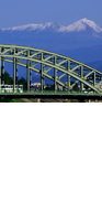 Asahi-bashi(Asahi-bridge). There are many rivers running through Asahikawa and as a consequence there are plenty of bridges. The most famous bridge in the city, “Asahi-bashi” connects the city center to the northern suburbs along Route 40 where the Ishikari and Ushubetsu rivers meet. Asahi-bashi is the one of the 3 most famous bridges in Hokkaido (the other two being the Toyohira-bashi in Sapporo,and the Nusamai-bashi in Kushiro) and the only one still unchanged since being built. It has been painted many times over 70 years with olive green the current choice. It was placed on the Hokkaido Heritage List in 2004 and recognized as the one of Asahikawa's top 8 scenic sites.
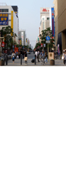 Asahikawa’s main street. Asahikawa’s main street starts from JR Asahikawa station for 10 blocks to the north, pedestrian only street, is called “Kaimono-Koen.” Its formal name is “Asahikawa Heiwa-dori Kaimono-koen” which directly translated means “Asahikawa Peace street Shopping park.” “Kaimono-Koen” was finished in 1972 and became Japan's first pedestrian only outdoor shopping mall. There are many shops and major department stores along Kaimono-Koen separating the business district on the east side and the restaurant and night life district on the west side. Although the city is suffering from an increasingly suburban life-style, Asahikawans still love to be in the city for going out and shopping. Most of Asahikawa's local buses use the bus stops close to Kaimono-Koen as a hub. Kaimono-Koen is a pedestrian-friendly street with both sides heated during winter for easy, non-slip walking.